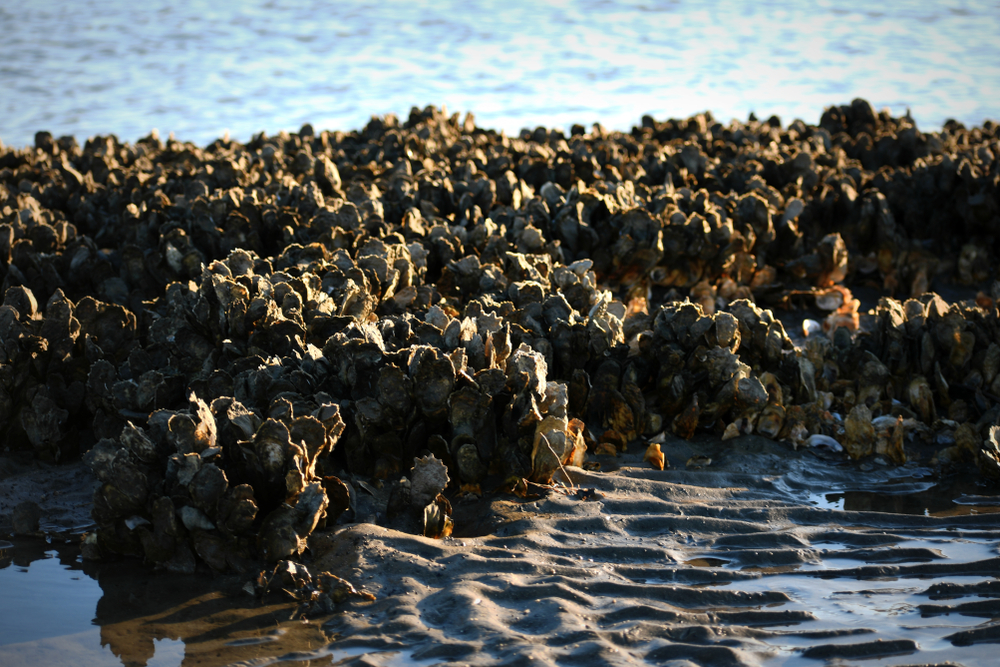
Can Interactive Mapping Tools Guide Shellfish Restoration?
Researchers in North Carolina have developed software that determines the best sites to reestablish oyster reefs, which create new marine habitats and prevent coastal erosion.
Can Interactive Mapping Tools Guide Shellfish Restoration?
Researchers in North Carolina have developed software that determines the best sites to reestablish oyster reefs, which create new marine habitats and prevent coastal erosion.
Oysters clean waterways by filtering pollutants such as microalgae and microscopic organisms in the water, and prevent erosion.by Shutterstock
Over the 19th and 20th centuries, oyster populations worldwide have been decimated; at least 85 percent of habitats have been lost due to overfishing, pollution and disease. Despite a recent rise in farming and eating oysters, their habitats have yet to recover. But with the help of interactive mapping tools, scientists and conservationists hope to restore oyster populations and the environmental benefits their habitats provide.
“In most places, including North Carolina, limited resources exist to restore habitats such as oyster reefs, and thus there was a need for an approach that integrated the best available data to direct restoration projects to the best locations, essentially asking the question, how do we maximize the bang for the restoration buck?” says Brandon Puckett, a research marine biologist with NOAA National Ocean Service.
In 2019, Puckett and a group of researchers from North Carolina State University launched a software mapping tool, designed to identify the best sites for re-establishing oyster reefs to ensure their ecological benefits.
Oysters are so much more than just delicious protein sources; they’re climate-friendly environmental superheroes. Oysters sequester carbon, clean waterways by filtering pollutants such as microalgae and microscopic organisms in the water, control the amount of phytoplankton in the water, create habitat for other marine life and even help prevent coastal flooding and erosion.
“Most restoration suitability models are focused on where to restore to maximize population enhancement benefits, which is a common goal of restoration efforts,” says Puckett. “However, there are other objectives that restoration practitioners pursue—such as improving water quality or stabilizing shorelines.” Puckett says their mapping technology looks to find locations suitable for restoring populations and enhancing water quality.
When they were developing the mapping or suitability tools, as Puckett calls them, researchers looked at similar mechanisms in use in the Chesapeake Bay and the Gulf of Mexico. They aimed to add on to existing technology after asking several partners what factors they thought were important. Their GIS-based device takes in a range of factors, including water salinity, dispersal of larval oysters and even distance from boat ramps.
In some ways, it’s similar to the interactive Connecticut Shellfish Restoration Story Map, a device developed by the state Department of Agriculture Bureau of Aquaculture, the state Department of Energy and Environmental Protection and The Pew Charitable Trusts, Connecticut Sea Grant launched in 2021 to aid shellfish restoration.
Full of photographs, the Connecticut map includes a physical GIS map and allows a user to zero in on an area by name or zip code to show multiple data layers of habitats, human uses, existing shellfish beds and other information such as areas where oysters may provide the most water quality benefits.
“We’d been interested in developing a plan for oyster bed restoration for the last five years,” says Tessa Getchis of Connecticut Sea Grant, UConn Extension. “But if we want to protect and grow them, we need to know what else is happening.”
Much of the data from the Connecticut tool is still in the early stages, as it was developed during the early part of the pandemic, when large percentages of people in the shellfish industry were out of work. At that time, Connecticut Sea Grant secured funding, purchasing oysters from farmers who would have otherwise had no customers. They planted those oysters back into beds and closed off the areas to encourage repopulation.
“We can look at fishing activity or farms or where pipelines are, where docks were built and the water quality and temperature,” says Getchis. “We’re still building that research, but we’ve put it together in this portal and we’re working to sort through what is the best information, how can we make it more user friendly for people to develop restoration projects.”
The waters off the Connecticut coastline, according to Getchis, are home to some of the largest and most productive native oyster beds in the world, but due to the scale of such an undertaking, as well as the lack of funding, no one had surveyed them in more than 100 years. The state is also unique in that many of the protected beds are used as seeds for farming, with farmers given specific standards as to which oysters they can use.
“We restored more than 2,000 acres. Some will serve the aquaculture industry, while some will remain closed,” says Getchis. That work is ongoing and, while not on as large of a scale, [CT Department of Agriculture’s Bureau of Aquaculture and partner agencies] are expanding the area for restoration.
The team is now looking into optimal shell density, doing restoration work in deeper waters where Connecticut has historically had oyster reefs and developing plans to continue monitoring the habitats.
In North Carolina, the state Division of Marine Fisheries is using mapping tools to plan multiple large-scale oyster restoration projects as part of the state’s oyster sanctuaries.
“These projects are designed with maximizing oyster population enhancement as the primary goal,” says Puckett.
The tool can also be tweaked to help with other restoration needs. Puckett says there’s already interest in creating individualized tools from states along the Gulf of Mexico, where the tool might identify locations for ‘living’ shorelines or inform the best areas for aquaculture farming.
Follow us
Republish!
![]()
Republish our articles for free, online or in print, under a Creative Commons license.

This work is licensed under a Creative Commons Attribution-NoDerivatives 4.0 International License.
Want to republish a Modern Farmer story?
We are happy for Modern Farmer stories to be shared, and encourage you to republish our articles for your audience. When doing so, we ask that you follow these guidelines:
Please credit us and our writers
For the author byline, please use “Author Name, Modern Farmer.” At the top of our stories, if on the web, please include this text and link: “This story was originally published by Modern Farmer.”
Please make sure to include a link back to either our home page or the article URL.
At the bottom of the story, please include the following text:
“Modern Farmer is a nonprofit initiative dedicated to raising awareness and catalyzing action at the intersection of food, agriculture, and society. Read more at <link>Modern Farmer</link>.”
Use our widget
We’d like to be able to track our stories, so we ask that if you republish our content, you do so using our widget (located on the left hand side of the article). The HTML code has a built-in tracker that tells us the data and domain where the story was published, as well as view counts.
Check the image requirements
It’s your responsibility to confirm you're licensed to republish images in our articles. Some images, such as those from commercial providers, don't allow their images to be republished without permission or payment. Copyright terms are generally listed in the image caption and attribution. You are welcome to omit our images or substitute with your own. Charts and interactive graphics follow the same rules.
Don’t change too much. Or, ask us first.
Articles must be republished in their entirety. It’s okay to change references to time (“today” to “yesterday”) or location (“Iowa City, IA” to “here”). But please keep everything else the same.
If you feel strongly that a more material edit needs to be made, get in touch with us at [email protected]. We’re happy to discuss it with the original author, but we must have prior approval for changes before publication.
Special cases
Extracts. You may run the first few lines or paragraphs of the article and then say: “Read the full article at Modern Farmer” with a link back to the original article.
Quotes. You may quote authors provided you include a link back to the article URL.
Translations. These require writer approval. To inquire about translation of a Modern Farmer article, contact us at [email protected]
Signed consent / copyright release forms. These are not required, provided you are following these guidelines.
Print. Articles can be republished in print under these same rules, with the exception that you do not need to include the links.
Tag us
When sharing the story on social media, please tag us using the following: - Twitter (@ModFarm) - Facebook (@ModernFarmerMedia) - Instagram (@modfarm)
Use our content respectfully
Modern Farmer is a nonprofit and as such we share our content for free and in good faith in order to reach new audiences. Respectfully,
No selling ads against our stories. It’s okay to put our stories on pages with ads.
Don’t republish our material wholesale, or automatically; you need to select stories to be republished individually.
You have no rights to sell, license, syndicate, or otherwise represent yourself as the authorized owner of our material to any third parties. This means that you cannot actively publish or submit our work for syndication to third party platforms or apps like Apple News or Google News. We understand that publishers cannot fully control when certain third parties automatically summarize or crawl content from publishers’ own sites.
Keep in touch
We want to hear from you if you love Modern Farmer content, have a collaboration idea, or anything else to share. As a nonprofit outlet, we work in service of our community and are always open to comments, feedback, and ideas. Contact us at [email protected].by Bridget Shirvell, Modern Farmer
January 23, 2023
Modern Farmer Weekly
Solutions Hub
Innovations, ideas and inspiration. Actionable solutions for a resilient food system.
ExploreExplore other topics
Share With Us
We want to hear from Modern Farmer readers who have thoughtful commentary, actionable solutions, or helpful ideas to share.
SubmitNecessary cookies are absolutely essential for the website to function properly. This category only includes cookies that ensures basic functionalities and security features of the website. These cookies do not store any personal information.
Any cookies that may not be particularly necessary for the website to function and are used specifically to collect user personal data via analytics, ads, other embedded contents are termed as non-necessary cookies.
For God’s sake let nature be.