A Win for Growers Who Protect Biodiversity on Agricultural Land
By mapping wildlife and endangered plant species on agricultural land, growers are empowered to make adjustments that don’t impede their productivity.
A Win for Growers Who Protect Biodiversity on Agricultural Land
By mapping wildlife and endangered plant species on agricultural land, growers are empowered to make adjustments that don’t impede their productivity.
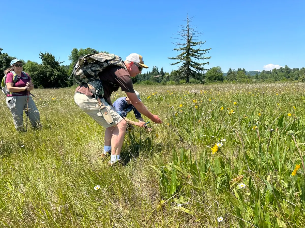
Maynard Mallonee looking at State Sensitive Wyethia angustifolia courtesy of Joe Rocchio
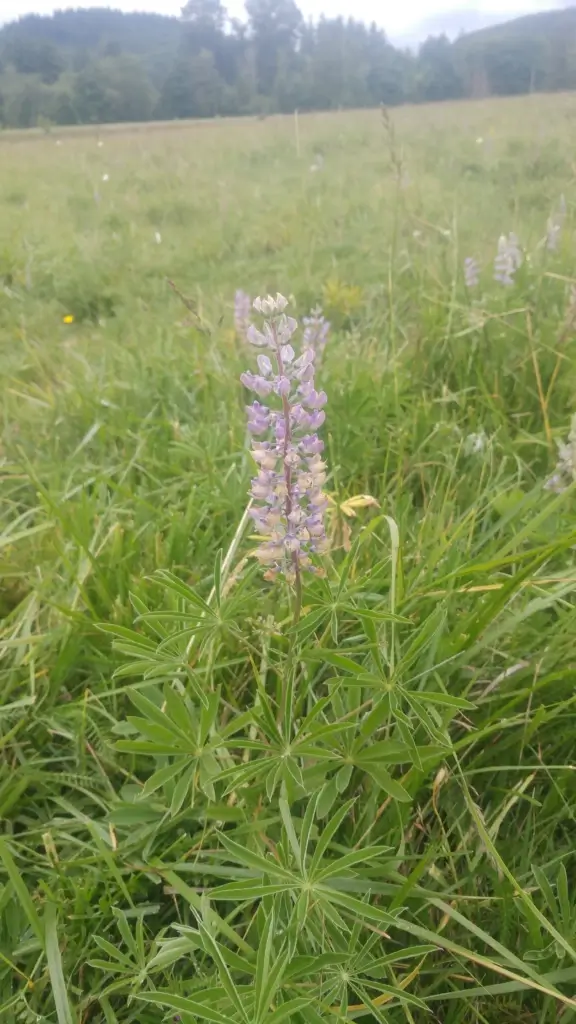
Truth be told, cattle farmers are no fans of lupine. If a pregnant cow chows down on the plant, its toxins can cause the unborn calf to be born with crooked cow syndrome and be unable to walk. In most instances, farmers will spray the plant with herbicide and kill it. But on Mallonee Farms, a Washington State dairy farm, things are different. Instead of eradicating the undesired plant, it is protected.
As a host to the larvae of the endangered Fender’s Blue Butterfly, Kincaid’s lupine was declared a threatened species under the federal Endangered Species Act in 2000. Only found in small areas of prairie grassland west of the Cascade Mountains, Mallonee Farms is the northernmost epicenter for the lupine in the US.
All across North America, endangered plant species and wildlife are struggling to survive on agricultural land. The United Nations Environment Programme has pegged the global food system and its encroachment on wildlife habitats, along with its use of fertilizers, pesticides and other chemicals, as directly threatening 86 percent of species at risk of extinction worldwide. In the United States, more than 50 percent of threatened or endangered species are vital pollinators such as the Fender’s Blue Butterfly. Without pollinators to fertilize berry crops, orchards or field crops such as squash, all of us eaters are also endangered. But, it’s not always easy for growers to identify those species at risk on their properties.
Until its discovery in 2004 by an eagleeyed employee of Washington State’s Department of Natural Resources cycling past one of the farm’s pastures, Maynard Mallonee had no idea the lupine on the family property was endangered.

NatureServe is a US-based not-for-profit organization that acts as a clearinghouse for biodiversity data. Through remote sensing such as wildlife cameras, collaring of wildlife, satellite imagery, drones, geographic information systems (GIS) and on-the-ground eyewitness observations, analysts can predict where wildlife and plant species at risk might be on agricultural land.
Compiled into maps, the information is used by government agencies such as state departments of natural heritage, fish and wildlife services, conservation organizations and individuals across North America to tailor responses that support at-risk species. These might include, as in the case of the Mallonee Farm, adopting rotational grazing practices or, in other instances, altering haying schedules. But nothing is full-proof and the surveying of private land is, after all, voluntary.
“We can’t survey everywhere,” says Regan Smyth, vice-president of conservation and science for NatureServe, “which makes a lot of things hard to know.”
She also admits that when it comes time to do on-the-ground surveys to verify the predictive data, growers can get a little ornery about sharing information. They worry about the inconveniences it might cause to production. After the lupine was discovered on the Mallonee family farm, the Department of Fish and Wildlife told Maynard Mallonee to come up with a rotational grazing plan for his cattle that protected the lupine.
“It’s big government telling you what to do,” says Mallonee, “and if you don’t do what they want, they can make life difficult.”
For the most part, Smythe says people managing land care about it and want to do the right thing. “Once people understand working lands need to be part of the picture of how we keep a diversity of life on the planet, then those who might in other circumstances not want people traipsing around their property become collaborators with Natural Heritage programs,” she says.

In Utah, the Wildlands Network uses mapping data to predict the migration corridors of wildlife. Hunter Warren is engagement coordinator for the organization and concurs with Smythe that there can be a mixed reaction from landowners when they learn that a migrating herd of mule deer, for example, will be stomping through their property. But once they learn that any adjustments needed to support the wildlife, such as replacing barbed wire fencing with fencing that won’t snag and harm an animal, will be paid for by the organization, they become more receptive.
Migrating herds of deer or elk, for example, can, through their grazing and trampling of the ground, break down organic matter into the soil, releasing nutrients that benefit crop production. Plants such as Kincaid’s lupine through their root systems create pathways in the soil that allows for enhanced water filtration and carbon sequester.
Bryan Gilvesy is CEO of the Alternative Land Use Services Program (ALUS), a non-profit organization working to help fund grower’s initiatives in six Canadian provinces and in Iowa that protect species at risk. He relates how in Southern Ontario a farmer discovered his hay field was home to 250 bobolinks, a bird assessed as being of special concern in Canada by the Committee on the Status of Endangered Wildlife in Canada and listed under the Species at Risk Act. A ground nesting bird, the bobolink prefers grasslands and prairies to lay its eggs. As more land is converted for agricultural use, the bobolink’s traditional nesting areas have become endangered. Combine or tractor harvesting destroys eggs and can even result in the deaths of birds. ALUS worked with the farmer to alter the haying schedule so that the fledgling bobolinks had time to grow.
“The farmer got a more mature hay crop and was rewarded financially,” says Gilvesy.

A report by The American Farmland Trust has concluded that managed agricultural land can support both food production and wildlife. It advocates for a broader approach to mapping biodiversity on agricultural land and enlisting the help of farmers and ranchers to do it with policies that embrace the USDA’s legacy of voluntary, incentive-based and locally led conservation.
On the Mallonee farm, the latest mapping shows a 33-percent increase in the lupine’s population. And although the farm’s grazing plan is having to be constantly updated and re-filed with the Department of Fish and Wildlife to accommodate the spread, Mallonee is happy he took the time and effort to protect the plant.
“In the beginning, maybe I might not have,” he says. But, without question, Mallonee is happy he did. The benefits of taking action to protect the lupine have been worth it. “The dairy farm is better managed through the rotational grazing methods we’ve developed,” he says.

Very cool to see farmers willing to try new methods. Farming is so high risk. I understand the reluctance to be told what to do. But when everyone wins including the natural world, then it’s a net positive.
The books are brief, with about 100 pages apiece that feature exquisite drawings.